Auf den Spuren der Räuber Wandern durch das Amt Rosengarten /
on the traces of the thieves walking through the Rosengarten district.
Wir haben in Bubenorbis im
Landgasthof „Sonne“ übernachtet. Das alte württembergische Gasthaus liegt ein
Stückweit Strecke weiter Richtung Hall ebenfalls an der Bundesstraße 14, die in
dem Bereich von Bubenorbis auf der bedeutenden Straße (Königsstraße) liegt, die
schon seit Jahrhunderten hier entlang führte. Bereits 1802 finden wir allerdings
die Bezeichnung „Sonnenwirth“ in einer Umgeldrechnung der Reichsstadt[1].
Damals schenkte das Wirtshaus in Bubenorbis immerhin doppelt soviel wie das an
der Roten Steige[2]
aus. Das große ehemalige Zoll- und Wirtshaus zeichnet sich durch ein
eindrucksvolles württembergisches Wappen über der Tür aus, welches auf die
Zugehörigkeit des Gebäudes zum Herzogtum und auf die Rolle als Zollstation
hindeutet. Einer der württembergischen Wirte im 16. Jh. ging als Böser Zöllner
von Bubenorbis in die Geschichte ein[3].
Wir beschlossen von der
historischen Straße abzuweichen und angesichts des Regens am Samstagmorgen
lieber durch den Wald zu gehen. Also stiegen wir von der sogenannten Kalten
Höhe herab bis in das von einem Bachlauf durchschnittene Tal, das uns an hoch aufragenden
Felswänden entlang führte. Von einer Kreuzung aus sahen wir oberhalb von uns
den Weiler Blindheim, der schon in der Karte von 1762 eingetragen ist. Der
Wanderweg führte dann kurz vor dem Standort des früheren Michelfelder Landturms[4],
an dessen Stelle heute ein Tierheim steht, auf die historische Königsstraße,
welche die Rote Steige hinab führt.
 |
| Wir stehen an der schönen Tür des ehemaligen Gast- und Zollhauses. - We are standing in front of the former inn and customs house. |
We spent the night in
Bubenorbis at the country inn “Sonne”. The old Wurttemberg inn lies a block far
down the road towards Schwäbisch Hall likewise at the B14, which covers the old
important road (the king’s road) which was here for centuries. However we find
the term “Sonnenwirth” in 1802 in taxation account of the imperial town[1]. At
that time the inn could pour out more than double of the quantity of the Red
steep track inn[2]. The large former customs house and inn distinguish itself by
an impressive coat of arms stone situated above the door, which underlines the
obedience to the duchy of Wurttemberg and the role as a customs house. One of
the inn keepers from the 16th century was well known to be the “evil
customs officer of Bubenorbis”[3].
We decided to leave
the road and preferred to walk through the wood as it was raining on that
Saturday morning. We descended from the so called Kalten Höhe (cold heights) in
the valley which was cleaved by a stream on a path along steep rising rocks.
Looking from a crossing upwards we saw the Blindheim hamlet which is depicted
on the map from 1762 too. The trail is leading on the old Königsstraße shortly
before the Landturm[4] and then down towards the red steep track. Today there is
an animal shelter at the former place of the Landturm of Michelfeld.
 |
| Wir sind unterwegs auf dem Weg durch das liebliche Tal an dem Bächlein. - We are on the path through the lovely valley next to a small stream. |
Die Gegend um den Landturm wurde
bisweilen als Aufenthaltsort von Räubern angesehen. Tatsächlich eignet sich die
Gegend durch die zerklüftete Topographie und einfach dadurch, dass sie schon
damals bewaldet war natürlich sehr gut zum Verbergen vor der Obrigkeit. Ein
direkter Zusammenhang des Räuberunwesens mit den Betreibern der Roten Steige
ist aber Sibylle Frenz nicht aufgefallen[5]
und auch ich habe in meiner Recherche über die letzten 10 Jahre nichts dazu
finden können. Ein Graben in der Nähe unseres Weges könnte auf die beim
Landturm verlaufende Heeg hinweisen wie sie bereits akribisch untersucht und
kartiert worden ist[6].
 |
| Einer der spannenden Steine entlang dem Weg unweit dem Ort des früheren Landturms. - One of those exciting Stones next to the path not far away from the place where the Landturm stood. |
From time to time the
area around the Landturm was viewed as residence of robbers. The rugged and
wooded topography indeed is suitable to hide from the authorities. Although an
explicit connection of the owners of the red steep track inn to the robbery could
not be discovered by Sibylle Frenz in her excellent publication[5]. I could not
find such hints during my over 10 years of research in the local archives
either. A ditch next to our path could be connected with the “Heeg” which was
running up to the Landturm during our period and which was examined and mapped
meticulously[6].
 |
| Wir rasten mitten in der Roten Steige zwischen "Landturm" und Roter Steige. - We have a break between the red steep track and the "Landturm". |
Hier war es sehr spannend zu
erleben, was denn diese Rote Steige über die ich schon so oft geschrieben habe,
eigentlich ist. Die Steige ist heute von einer schmalen asphaltierten Straße
überbaut, welche ab dem Standort des Landturms sehr steil abfällt. Durch die
asphaltierte Straße konnte man leider nichts von der in den Schriftquellen
auftauchenden Rotfärbung der Straßenoberfläche beim Steigengasthaus sehen. Der
Nachfolgebau des heute im Freilandmuseum Wackershofen stehenden
Steigengasthauses[7]
wird nebst einigen Wirtschaftsgebäuden noch immer landwirtschaftlich genutzt,
was auch sehr interessant war zu sehen. Unweit des Wohnhauses, welches ab der
Mitte des 19.Jahrhunderts als Steigengasthaus fungierte, weideten einige
Limpurger Rinder wie man sie auch im Freilandmuseum hält. Wir folgten der
Beschilderung nach Michelfeld, obwohl ich eigentlich gern einen Abstecher nach
Leoweiler und Molckenstein[8]
gemacht hätte. Von der Roten Steige aus hat man einen herrlichen Blick auf den
nördlichen Teil des früheren Amtes Rosengarten. Michelfeld ist ein
offensichtlich wachsendes Dorf. Der Ortskern weist allerdings nach wie vor
einige schöne historische Bauten auf. Die Dorfkirche mit ihrem mächtigen
Kirchturm beherbergt die Grabsteine einiger bedeutender früherer Einwohner. So
fanden wir dort den Grabstein des Pfarrers Carl Abrecht Glaser, der im 18.
Jahrhundert in Michelfeld tätig war und das erstaunliche Alter von 118 Jahren
erreichte.
 |
| Ein schöner Blick hin nach Leoweiler. Noch war es regnerisch. Im Hintergrund die Höhenkette Richtung Einkorn. - A nice view towards Leoweiler. It was still rainy. Note the heights of the Einkorn. |
It was very exciting
to learn on site what the steep track really is after reading and writing so
much about it. The steep track today is overbuilt by a narrow asphalted road,
which is steep sloping just from the former area of the Landturm. The asphalt
makes it impossible to see something of the red colour of the former road
surface near the steep track inn. The successor building of the old steep track
inn[7] (today in the open air museum Wackershofen) along with some economic
buildings is still in use agriculturally, which was very interesting to notice.
Some Limpurg cattle grazed close to the building which was functioning as the
red steep track inn since the mid-19th century, such as they are in
the open air museum Wackershofen too. We followed the signposting to Michelfeld
although I felt tempted to make an excursion to the hamlets of Leoweiler and
Molckenstein[8]. You have a magnificent view from the red steep track on the
Northern part of the former Rosengarten district. Today Michelfeld obviously is
a growing village. Nevertheless the centre of the village still has some very
nice historical buildings. The church of the village has an impressive tower
and includes the grave stones of some important former inhabitants. We found
the gravestone of the pastor Carl Albrecht Glaser which was active during the
18th century and reached the age of 118 years.
 |
| Der Grabstein von J.L.L. Glaser und seinem Vater Carl Albrecht Glaser, beide Pfarrer von Michelfeld. - The gravestone of J.L.L. Glaser and his father Carl Albrecht Glaser both pastors of Michelfeld. |
Der Regen hatte aufgehört. Deswegen konnten wir
südlich von Michelfeld auf einer leichten Anhöhe eine Vesperpause einlegen.
Das Wirtshaus im Dorf hatte ohnehin ausgesehen als wäre es gerade geschlossen[9].
Es wäre interessant wie alt das Gasthaus ist und ob es sich um das Mitte des
18. Jahrhunderts in Comburger Hand befindliche Michelfelder Wirtshaus handelte[10].
Von einem erhöhten Punkt nahe Bibersfeld fiel es mir auf, weshalb 1749 just die
Bibersfelder zur Roten Steige liefen, um einem Befehl des Rats nachzukommen und
etwa den Wirtsleuten beizustehen[11].
Man hatte von dort aus einfach einen hervorragenden Blick auf die Rote Steige,
während Michelfeld eher hinter der Anhöhe verschwindet bzw. nur der Kirchturm
deutlich sichtbar ist.
The rain subsided. Therefore we decided to make a break for a snack at a slight rise South
from Michelfeld. The inn within the village has looked as it was closed anyway[9].
It would be interesting to learn how old the tavern is and if it is the same as
the tavern in Michelfeld which existed during the 18th century and
which was in the hands of Comburg[10]. It was very exciting to realize from the top
of a higher point near Bibersfeld why maybe the inhabitants of Bibersfeld were
running towards the red steep track in 1749 to obey to the order of the
magistrate to support the owners of the inn[11]. It’s obvious that you have a very
good view from there towards the red steep track while the village of
Michelfeld lies behind a ridge and only the church’s tower is clearly visible.
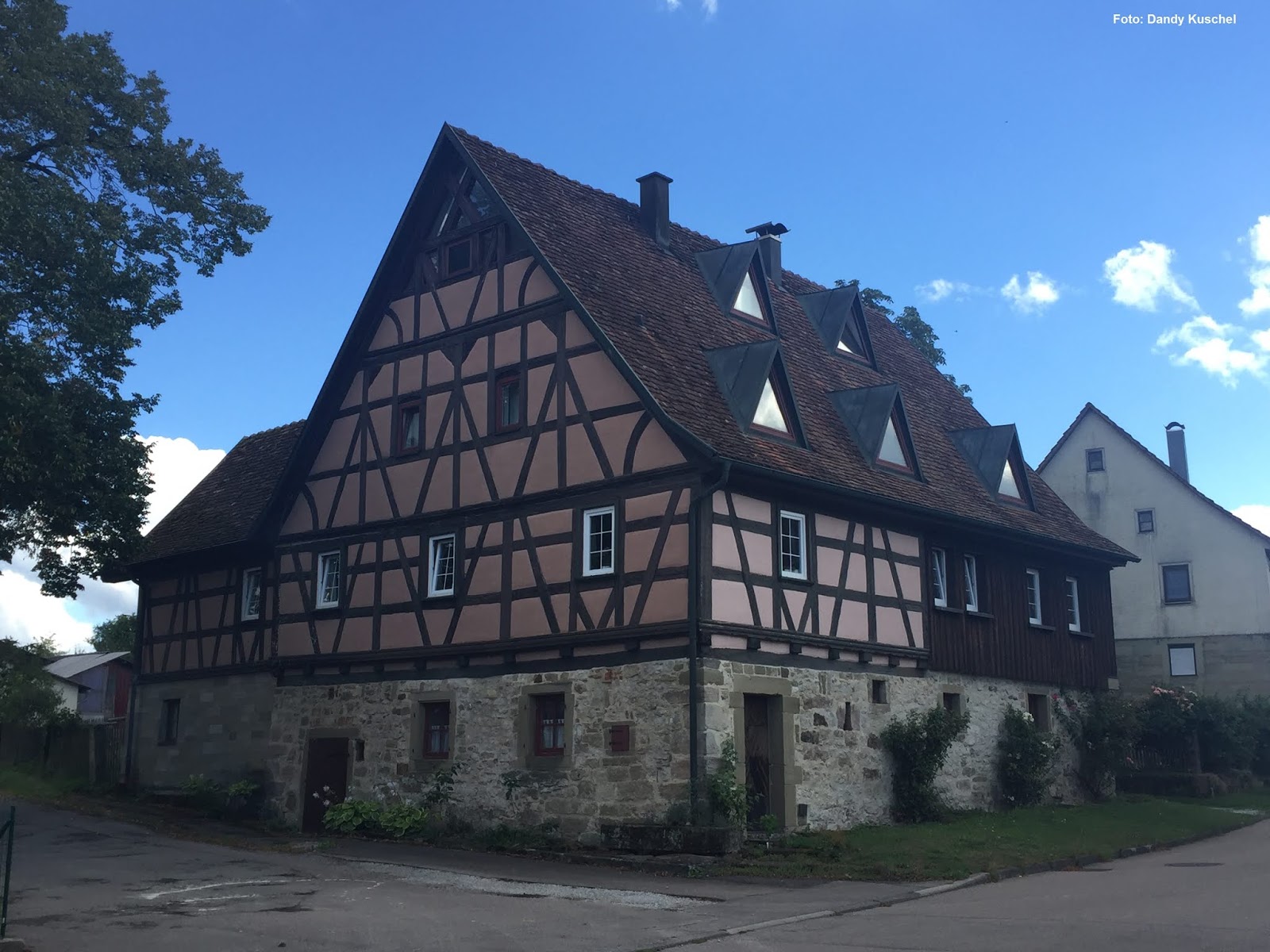 |
| Ein schönes Fachwerkhaus in Raibach. - A nice half-timbered house in Raibach. |
Wir überquerten sodann auf
Wirtschaftswegen die Felder und Wiesen bis wir nach Raibach kamen. Der Weiler
hat noch eine beachtliche Anzahl alter Gebäude. Mitte des 18. Jahrhunderts gab
es etwa 10 Haushalte mit zahlreichen Hausgenossen[12].
Unser eigentliches nächstes Etappenziel war allerdings Tullau. Das etwas
überraschende für mich war, dass der Ort erst von sehr nahem zu sehen ist, wenn
man von Raibach her kommt. Das liegt daran, dass er westlich von einem Wäldchen
begrenzt wird. Dieser entstand in Folge des Verschwindens des Weinbaus bei Tullau
um die Mitte des 18. Jahrhunderts[13].
Der Weg fiel steil zum malerisch gelegenen Ort herab. Das Ortsbild wird zum
einen vom Schloss Tullau und zum anderen von der Kirche geprägt. Das Schloss
wechselte im 18. Jahrhundert mehrfach den Besitzer und war zeitweise im Besitz
der bedeutenden Haller Patrizierfamilie Feyerabend. Im Ortskern angekommen fiel
mir die Darstellung von Weinkanne und –glas an einer Hauswand ins Auge. Ich
freute mich über das schöne Fachwerkgebäude und der Eigentümer, der es gerade
anstrich, bestätigte dass es sich einmal um das Wirtshaus gehandelt habe. Wir
kamen ins Gespräch und der freundliche Herr wusste viel über sein Haus und die
Ortsgeschichte zu erzählen. Immerhin reicht die Geschichte des ehemaligen
Wirtshauses bis zurück ins 16. Jahrhundert und sehr alte Teile des Hauses sind
noch erstaunlich gut erhalten. Besonders faszinierte mich, dass man wieder die
schönen Fenster wie wir sie aus dem Haus aus Zaisenhausen kennen[14]
im ersten Obergeschoss einsetzte. Vielen Dank an dieser Stelle nochmal für die
freundliche Bewirtung und die Vermittlung der spannenden Quelle von Gerd
Schäfer (siehe Verweise!). Wir nahmen dann auch noch das Schloss in
Augenschein, welches einen sehr gut erhaltenen Eindruck macht. Es ist heute in
Privatbesitz. Die Kirche war zugänglich und bestach durch einen sehr
beeindruckenden Innenraum. Sie liegt heute am Jakobsweg und man kann sich dort
einen Stempel abholen.
 |
| Ein Blick aus der Ferne auf Tullau. - A view on Tullau from a distance. |
 |
| Die Kanne und das Glas am alten Wirtshaus in der Kirchgasse. - The jug and the glass at the old inn in the Kirchgasse. |
 |
| Ein näherer Blick auf einen Flügel des Schlosses von Tullau. Besonders die Höhe des Gebäudes fanden wir sehr beeindruckend. - A close view on a wing of the castle of Tullau. Especially the hight of the building is very impressive. |
We crossed the fields
and meadows on farm roads until we arrived in Raibach. The hamlet (although
today more in the size of a village) has a remarkable number of old buildings.
In the mid-18th century there were round about 10 households and a
large proportion of residents (so called “Hausgenossen”)[12]. But Tullau was our next real goal. It was astonishing for me that the place is only visible if you
are very close to it, if you are coming from Raibach. That’s the result of the
fact that the place is confined by a small wood at the western edge of it. That
wood emerged subsequently when the wine growing disappeared in Tullau at the
middle of the 18th century[13]. The path is very steep sloping to the
very picturesque situated location. The scape of the hamlet is very much shaped
by the castle of Tullau and the church. The owners of the castle changed for
several times during the 18th century and at times was in the
possession of the important Feyerabend patrician family of Hall. I noticed the
depiction of a wine glass and a wine jug at a house wall, when we arrived at
the center of the place. I was very happy about a nice timber framed building.
The owner who was just painting the wall confirmed that the house was the
former tavern of the hamlet. We were talking in a very positive and enjoyable
manner and he could tell a lot about the local history and especially the
history of his house. The history of the former tavern leads at least back into
the 16th century and some very old parts of the house are made in a very
astonishing constitution. I was especially fascinated by the nice windows
which were placed into the house as we know such windows from the house of
Zaisenhausen[14]. Many thanks here for the friendly hospitality and the sending of
the very exciting source by Gerd Schäfer (check the references below). We had a
close look on the castle too, which made a very good preserved condition. Today
it is in private property. The church was open and it was even more impressive
by the interior. She lies on the way of St. James and you can get a stamp
imprint there.
 |
| Zwei von uns am Eingang der Kirche von Tullau. - Two of us at the entry of the church of Tullau. |
 |
| Ein Wandbild in der Kirche von Tullau. - A painting on a wall of the church of Tullau. |
 |
| Typisch für Schwäbisch Hall die Wappen der Reichsstadt in der Kirche von Tullau. - It's typical for Schwäbisch Hall to find the coat of arms of the imperial town in the church of Tullau. |
 |
| Der Altar in der Kirche von Tullau. - The altar in the church of Tullau. |
Der Weg entlang dem Kocher war teilweise etwas
schwierig, da man teils auf der schmalen Straße gehen musste.
Diese Straße existiert erst seit 1840. Im 18. Jahrhundert ist man, wenn man fahren wollte von Schwäbisch Hall über die Raibacher Steige gegangen. Die katholischen Comburger Untertanen hingegen konnten damals den Kocher durch eine Furt durchqueren und so auf einem Fußweg zum Beispiel zur Kirche nach Steinbach gehen[15].
Kurz vor Unterlimpurg wechselten wir die Kocherseite und gelangten durch den Unterlimpurger Vorstadt zurück nach Schwäbisch Hall zum Gasthof „Zum Goldenen Adler“ am Markt.
The way along the
Kocher River was very difficult in some sections as we partly had to walk on
the narrow road.
That road exists since 1840. During the 18th century travellers with coaches or carts had to use the Raibach steep track. The catholic subjects of Comburg however could cross the Kocher river through a ford and walk on a foot path for example to got to the church of Steinbach[15].
We changed the side of the Kocher shortly before Unterlimpurg and passed through the Unterlimpurg suburb before arriving in the hotel “Zum Goldenen Adler” (the golden eagle) at the market place.
 |
| Zurück in Schwäbisch Hall. Ein Blick über den Kocher zur Johanniterkirche links und im Hintergrund rechts das Weilertor. - Back in Schwäbisch Hall. A view over the Kocher river towards the Johanniterkirche and in the background the Weilertor (hamlet's gate). |
Generell waren diese zwei Tage
sehr interessant. Wir haben festgestellt, dass die Beschilderung in den Wäldern
etwas besser sein könnte und insbesondere, wo man auf keine Ortskundigen trifft
seine Schwierigkeiten hat von einem Ort zum anderen zu gelangen, wenn man vor
allem vermeiden will an einer Straße entlang zu laufen. Die Strapazen an einem
heißen Sommertag von Wackershofen nach Bubenorbis zu laufen, habe ich
vielleicht ein bisschen unterschätzt. Der Rückweg verlief deutlich entspannter.
Sehr danken möchte ich meinen beiden Mitstreitern wie auch den freundlichen
Leuten, denen wir unterwegs begegnen durften wie insbesondere im Lemberghaus
(Haus der Naturfreunde), am Sportplatz von Michelfeld und im ehemaligen
Wirtshaus von Tullau.
Leider habe ich von dem darauf
folgenden Tag an dem wir noch zum Einkorn gewandert sind keine Bilder[16].
Vielleicht dennoch ein andermal mehr über den Einkorn und das Stift Comburg.
Both days were very
interesting in general. We remarked that the signposting in the woods could be
a bit better. It was especially difficult to walk from one village to another
if we could not meet locals and when we wanted to avoid walking on the car
roads. Maybe I underestimated the hardships to walk from Wackershofen to
Bubenorbis on a very hot summer’s day. The way back was a lot more relaxed.
I want to thank very
much both of my comrades as much as all the friendly people we could meet
during our trip especially in the Lemberghaus (house of the friends of the
nature) and at the sports ground of Michelfeld and finally at the former tavern
of Tullau.
Unfortunately I didn’t
made photos on the following day, when we walked to the Einkorn[15]. Perhaps I will
report about this place and the “Stift Comburg” on another occasion.
Bitte beachtet unseren Aufruf zur
Hilfe für das Freilandmuseum Wackershofen: https://wackershofenannodomini.blogspot.com/2020/04/wie-geht-es-weiter-mit-dem-blog-how.html
Please notice our call for help for the open
air museum Wackershofen:
Fotos: Dandy Kuschel und André Hanselmann
Text: André Hanselmann
[1] Umgeldrechnung
auf dem Land 1801/02, Stadtarchiv Schwäbisch Hall, Sig. 4/1535 S. 9 f
[2]
Ebenda S. 9
[3] G.
Dürr: „Der böse Zöllner und die Metzger von Hall“ Haalquell Nr. 14, Nr. 15, Nr.
16
[4]
Der Landturm gehört zur Grenzbefestigung der Landheeg. Es gab nur wenige
Landtürme von denen nur der von Hörlebach erhalten geblieben ist. / The Landturm (country’s tower) belonged to
the border fortification. There were only a few of Land-towers
of whom only the tower at Hörlebach is still existing today.
[5] Sibylle Frenz: “War das
Steigengasthaus ein Räubernest?” in „
Mitteilungshefte des Vereins Hohenloher Freilandmuseum“ Bd. 16, Freilandmuseum
Wackershofen, Schwäbisch Hall, 1995
[6]
Mattern & Wolf S. 69-75
[7]
Siehe das Bild hier: https://wackershofenannodomini.blogspot.com/2020/06/hochbau-im-18-jahrhundert-building.html
[8]
Das Thema war bei uns schon die Ernte der Molckensteiner Wiese. Vergleiche / The work on the Molckenstein meadow once was a topic of our event. look
into: https://wackershofenannodomini.blogspot.com/2015/11/anno-domini-1763-endlich-frieden-23-25.html#more
[9] Der Landgasthof „Adler“ in
Michelfeld hat laut Südwestpresse seit Juni 2020 geschlossen. / The „Adler“ country inn at Michelfeld is
closed since June 2020 according to the Southwestern Press. Quelle/Source: Maya Peters: „Adler und Alte
Küferei – Gastronomen-Brüder hören auf“ swp 1. Juni 2020
[10]
Michelfeld hatte nur ein Wirtshaus, wenn man der Sicht des Haller Rates im
Prozess mit Würzburg folgt, welche das Steigengasthaus an der Roten Steige als
außerhalb Michelfeld gelegen bezeichnete.
[11]
André Hanselmann: „Landfriedensbruch an der Roten Steige?“ Kleine
Schriften aus dem Hohenloher Freilandmuseum Nr. 21, 2014
[12]
Amtsrechnung Amt Rosengarten 1759, Stadtarchiv Schwäbisch Hall
[13]
Gerd Schäfer: „Weinbau, Keltern und Gasthaus in Tullau“ Dokumentationsbeiträge
zur Tullauer Ortsgeschichte, Band 1, 1996, S. 11-15
[14]
Schaut mal hier z.B. auf die Fensterreihe von innen. / Just look here on the row of windows from inside: https://wackershofenannodomini.blogspot.com/2019/04/landleben-1619-teil-3-part-3.html
[15] Gerd Schäfer, S. 26
[15] Gerd Schäfer, S. 26
[16]
Ich hatte keine Speicherkarte in der Kamera. ;-) / I forgot the memory Card of my camera.
Andrè, your travelogue and serene landscape photos are very much appreciated. This would be a wonderful place to visit one day. You tempted me to use Google Maps to see exactly where the places you referenced.
AntwortenLöschenThank you!
I'm glad that you like it. Swabia (or this part of Franconia) is a Region in Germany which is not so well known to American tourists and therefore maybe makes a more "untouched" impression.
LöschenCheers,
Some beautiful scenes. Especially the last picture. Thank you for sharing your journey.
AntwortenLöschenYes, Schwäbisch Hall is such a postcard-town (although German documentaries more often focus on another part of the old city.
LöschenAndre, some great 'photos there of some wonderful buildings and interiors, with nice info on the history too.
AntwortenLöschenI will transmit your kind words about the photos especially to Mr. Kuschel, who made most of them. I'm glad that you like my other Content too and not my wargaming stuff only. Many thanks for your comment.
LöschenCheers!